

Project Design Purpose : The primary objective of this project is to simulate parts of the core functional components of an aviation ADS-B (Automatic Dependent Surveillance–Broadcast) system within the Mini OT Aviation CAT-II Airport Runway Simulation Cyber Range (version : v_0.2.2). Rather than replicating a full operational ADS-B infrastructure, the project focuses on modeling the airport ADS-B ground station’s antenna and controller's function to support the OT training, experimentation, and security-oriented analysis.
This article is organized into three main sections:
-
Background Information about ADS-B : A concise overview of the ATC ADS-B system and the specific functions simulated within the aviation cyber range system.
-
Ground Station ADS-B Controller Design : The architecture and communication logic of the simulated ground station ADS-B controller and the interaction with other components in the cyber range.
-
User Interface of ADS-B Information : The design and visualization of surveillance data as presented on the tower’s ATC HMI (human machine interface) ATC panel.
Important : The real ADS-B is significantly more complex than the implementation shown in this project. Within this cyber range, we distill (this is NOT a 1:1 emulation as the digital twin) the essential system behaviors, logic, Human–Machine Interface(HMI), and cybersecurity scenarios without the overhead of full avionics fidelity.

# Author:      Yuancheng Liu
# Created:     2025/12/20
# Version:     v_0.2.3
# Copyright:   Copyright (c) National Cybersecurity R&D Laboratory (NCL)
# License:     GNU General Public License V3
Project Introduction
The Automatic Dependent Surveillance–Broadcast (ADS-B) system represents a cornerstone of modern air traffic surveillance. Unlike traditional secondary surveillance radar (SSR), which relies on ground-based interrogation, ADS-B is automatic (requiring no external stimulus), dependent on high-precision Global Navigation Satellite System (GNSS) data for positioning, and broadcast-based. This architecture allows aircraft to periodically transmit their state vector—including identity, altitude, velocity, and precise coordinates—to both ground stations and other nearby aircraft, creating a shared, real-time tactical picture of the airspace.
In the development of Mini OT Aviation CAT-II Airport Runway Simulation Cyber Range System, simulating the function of the ADS-B is a critical request. As illustrated in the diagram below, the cyber range specifically simulates the Ground Station Segment (highlight in the red rectangle) of the broader ADS-B ecosystem.

Original image source link : https://www.sportys.com/blog/ads-b-101-what-you-need-know/?srsltid=AfmBOorXll9byFukKBcTwg5EilCH3MslsuXFGzUCiaYz9Hbk3wRUY4KbThe simulated ground station automatically receives ADS-B messages broadcast by cyber range's aircraft simulator operating in the airport’s surrounding airspace. These data are decoded and processed by the ground station controller to extract mission-critical surveillance information/message. Then this data will be visualized on a airport tower ATC Human-Machine Interface (HMI) with a radar-style Air Traffic Control (ATC) display. This setup allows the cyber range users to interact with realistic air traffic flows and analyze the integrity of data exchange within a controlled, simulated environment.
In parallel, the project integrates airport weather and environmental sensors' data into the ground station controller. The controller aggregates this information and broadcasts airport status and weather data back to the nearby aircraft, reflecting the bidirectional information exchange commonly found in modern aviation communication systems.
Technical Implementation Introduction
The core logic of the Ground Station ADS-B Controller is implemented using the project Python Virtual IEC 62541 OPC-UA-TCP PLC Simulator. In this implementation, the OPC UA protocol is used to simulate the communication channel between the ADS-B ground station controller and the airport tower ATC HMI, reflecting how modern airport subsystems exchange operational data through standardized industrial protocols.
For airport weather data acquisition function, the system integrates live meteorological information by querying the Google Weather API based on the airport’s configured geographic location (city). The retrieved weather parameters—such as wind conditions, visibility, and temperature—are normalized and saved into the ground station controller as sensor inputs, emulating data streams typically produced by the airport weather radars and environmental monitoring systems.
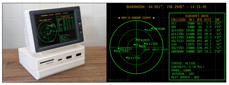
The tower ATC control HMI is implemented by following the visual and interaction design introduced in the Retro-ADSB-Radar project. The interface presents both received aircraft ADS-B messages and broadcast airport information using a combined list-based view and a radar-style Air Traffic Control (ATC) display, as shown in Figure below.
These implementation choices ensure that the aviation cyber range simulates not only ADS-B message exchange, but also the underlying Industrial Control Systems (ICS) and Operational Technology (OT) communication patterns that modern airports rely on. This layered design makes the platform well suited for OT system security training, system behavior analysis and experimentation.
Background Knowledge of ADS-B
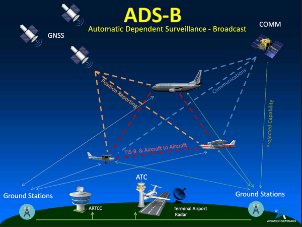
Automatic Dependent Surveillance–Broadcast (ADS-B) is a core surveillance technology used in modern aviation to enhance air traffic monitoring, situational awareness, and operational efficiency. Extensive documentation and learning resources are publicly available, such as the FAA ADS-B manuals and educational materials, as well as introductory videos explaining system concepts and operational use. The main connection diagram is shown below:
Rather than duplicating those materials, this section focuses on summarizing the key features of ADS-B and clearly defining the subset of ADS-B information and behavior simulated in the aviation cyber range.
ADS-B Key Feature Over View
ADS-B (Automatic Dependent Surveillance–Broadcast) is modern aviation tech where aircraft use GPS to automatically broadcast their precise location, speed, and altitude, replacing or supplementing radar for Air Traffic Control (ATC) and other planes. It's "Automatic" (no pilot input), "Dependent" (on GPS), "Surveillance" (tracks aircraft), and "Broadcast" (sends data out). Key parts are ADS-B Out (transmitting) and ADS-B In (receiving traffic/weather info in the cockpit), enhancing safety, capacity, and efficiency globally.
How ADS-B Works:
-
GPS-based: Aircraft get precise position from satellite navigation.
-
Broadcasts Data: Transmits position, altitude, speed, and ID via 1090 MHz or 978 MHz frequencies.
-
Ground & Air Reception: Ground stations and other aircraft receive these signals.
-
No Interrogation: Unlike radar, it doesn't need a signal from the ground to trigger a response.
Key Components :
-
ADS-B Out : Refers to the transmission of aircraft state data from the aircraft to ground stations and other aircraft. ADS-B Out is mandatory in many controlled airspaces and forms the backbone of modern air traffic surveillance.
-
ADS-B In : Refers to the reception of traffic and weather information by the aircraft, typically displayed in the cockpit, tower HMI to improve pilot and tower ATC officer situational awareness.
Benefits of ADS-B :
-
Better Safety: More accurate and frequent position updates reduce the risk of mid-air collisions.
-
Increased Capacity: Precise tracking allows aircraft to safely operate closer together, improving airspace utilization.
-
Cost-Effective: ADS-B ground infrastructure is generally less expensive to deploy and maintain than radar systems.
-
Situational Awareness: Pilots receive real-time traffic and weather information directly in the cockpit.
For the standard ADS-B message frame is 112 bits long and consists of five main parts, shown as follows:
+----------+----------+-------------+------------------------+-----------+
|  DF (5)  |  CA (3)  |  ICAO (24)  |         ME (56)        |  PI (24)  |
+----------+----------+-------------+------------------------+-----------+
In this project current version (v_0.2.3), we haven't implement the ADS-B message encoding and decoding part, we will add these feature in the future version.
The detailed message information please refer to this link : https://mode-s.org/1090mhz/content/ads-b/1-basics.html
ADS-B Data Simulated in the Aviation Cyber Range
In the aviation cyber range environment, only a selected subset of ADS-B data and behaviors is implemented. The goal is to model essential operational information flows rather than fully replicate certified avionics systems.
Simulated ADS-B Out Data (Aircraft → Ground Station / Other Aircraft)
The following aircraft state information is broadcast by simulated aircraft:
| Index | ASD-B Value Name | Data Description |
|---|---|---|
| 0 | Current Flight Pattern ID | Aircraft identifier and the active flight pattern. |
| 1 | Current ATC State | Operational state of the aircraft, such as: Landing, Hovering, Waiting, Taking Off, On Taxi, Enter Area, Fueling. |
| 2 | GNSS Position Information | Aircraft latitude and longitude coordinates derived from simulated satellite navigation inputs. |
| 3 | Current Altitude | The vertical position of the aircraft relative to mean sea level, typically expressed in feet. |
| 4 | Aircraft Heading Direction | The direction in which the aircraft’s nose is pointing, expressed in degrees relative to true north. |
| 5 | Course Over Ground (COG) | The actual direction of movement of the aircraft over the ground, expressed in degrees relative to true north. |
| 6 | Speed Over Ground (SOG) | The horizontal speed of the aircraft relative to the ground, typically expressed in knots. |
| 7 | Airspeed | The speed of the aircraft relative to the surrounding air mass. |
| 8 | Fuel State | The remaining fuel quantity of the aircraft, expressed as current fuel capacity and percentage of total fuel remaining |
Simulated ADS-B In / ACARS-Like Data (Ground Station → Aircraft)
The ground station aggregates airport operational and environmental data and broadcasts it to nearby aircraft, conceptually similar to ADS-B In and ACARS information services.
Airport Operational Information
| Index | ASD-B Value Name | Data Description |
|---|---|---|
| 0 | Airport Identifier | A unique airport code (e.g., ICAO-style identifier) used to associate the broadcast information with a specific airport and airspace. |
| 1 | Runway Approach GPS Location | The geographic coordinates defining runway approach points or thresholds. |
| 2 | Current Traffic and ATC Operational State | A summarized representation of airport traffic conditions and ATC status. |
Airport weather data is provided as part of the ground station broadcast to support flight safety and operational planning.
Airport Weather Information
| Index | ASD-B Value Name | Data Description |
|---|---|---|
| 0 | Surface Wind | Reported as direction (true north degrees) and speed (typically in knots, sometimes meters per second). |
| 1 | Horizontal Visibility | Measured in meters (international), representing the greatest horizontal distance at which objects are identifiable. |
| 2 | Runway Visual Range (RVR) | An instrument-derived value representing the horizontal distance a pilot can see down the runway, typically reported when visibility drops below 1 mile or 1,500 meters. |
| 3 | Sky Condition (Clouds) | Includes cloud cover amount (FEW, SCT, BKN, OVC) and the height of the cloud base in hundreds of feet above ground level (AGL). |
| 4 | Air Temperature | Reported in whole degrees Celsius. |
| 5 | Altimeter Setting (Pressure) | Current barometric pressure at the station, used by pilots to calibrate aircraft altimeters. It is measured in hectopascals (hPa). |
| 6 | Precipitation | Rain (RA), Drizzle (DZ), Snow (SN), Snow Grains (SG), Ice Pellets (PL), Ice Crystals (IC), and Hail (GR). |
| 7 | Obscurations | Fog (FG), Mist (BR), Haze (HZ), Smoke (FU), Volcanic Ash (VA), and Dust (DU). |
Ground Station ADS-B Controller Design
The Ground Station ADS-B Controller is the central coordination component of the aviation cyber range, responsible for integrating airspace and ground aircraft surveillance data, airport operational status, and environmental sensor information. It bridges the physical-world simulation layer, the ADS-B communication layer, and the tower ATC HMI, enabling realistic air–ground information exchange while remaining suitable for digital experimentation and cybersecurity analysis.
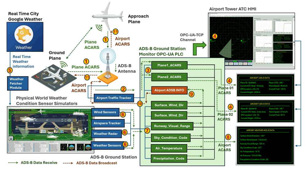
The figure below shows the end-to-end workflow of the simulated ground station ADS-B system, highlighting both ADS-B Out (aircraft surveillance in green color) and ADS-B In (airport information broadcast in orange color) data paths.

The ground station ADS-B system in the cyber range consists of four main modules, each representing a distinct functional domain commonly found in real-world airport infrastructure.
Google Weather Info Fetcher Module
This module periodically connects to the Google Weather service to retrieve real-time meteorological data based on the airport’s configured geographic location (city). The fetched data serves as the external environmental input for the cyber range and is forwarded to the aviation physical world simulator for sensor-level abstraction.
Aviation Physical World Simulator
The physical world simulator emulates the airport environment and surrounding airspace, including:
-
Simulated aircraft generating ADS-B Out messages
-
Ground ADS-B antenna for message reception and broadcast
-
Airport traffic tracker
-
Wind sensors
-
Airspace weather condition tracker
-
Weather radar and weather metering units
This module converts external weather data and aircraft state changes into sensor-like readings, providing realistic inputs to the ADS-B controller without relying on physical hardware.
Ground Station ADS-B Controller (PLC)
The Ground Station ADS-B Controller represents the OT control logic layer of the system. It is implemented using the Python IEC 62541 OPC-UA-TCP Virtual PLC Simulator framework : https://www.linkedin.com/pulse/python-virtual-plc-simulator-iec-62541-opc-ua-tcp-protocol-liu-pm1pc, The controller performs the following core functions:
-
Receives aircraft ADS-B–derived information from the physical world simulator
-
Collects and processes weather sensor and radar data
-
Converts operational and environmental data into ADS-B / ACARS-style information
-
Synchronizes all data into a structured OPC UA address space
-
Publishes real-time information to the tower ATC HMI
-
Sends airport ADS-B information back to the ADS-B antenna for broadcast
Airport Tower HMI ADS-B Display Panels
The Airport Tower ATC HMI retrieves all ADS-B and weather information from the ADS-B controller via OPC UA. After decoding and formatting the data, the HMI presents information across three primary display panels:
-
Radar Display Panel – Visualizes all aircraft currently relevant GNSS Position within the controlled airspace.
-
Aircraft ADS-B Information Panels – Displays detailed ADS-B data for each aircraft report to the airport ground station.
-
Airport Weather ADS-B Panel – Shows weather and environmental conditions within the airport’s Class B airspace area.
Ground Station ADS-B System Workflow
The detailed system work flow is marked with different steps in the below diagram:
Ground Station ADS-B Out Workflow
The simulated ADS-B Out workflow (Aircraft → Ground Station → ATC HMI) focuses on aircraft surveillance data flowing from aircraft to the ground station and onward to the ATC HMI. The process consists of the following steps:
-
Step 01 – Generate Aircraft ADS-B Information : The aviation physical world simulator generates ADS-B Out information for each simulated aircraft based on its current operational state (position, altitude, speed, heading, fuel state, and ATC status), as defined in the simulated ADS-B Out data model.
-
Step 02 – ADS-B Data Conversion and Preprocessing : The generated ADS-B messages are received by the simulated ADS-B antenna and preprocessed by the airport traffic tracker. The messages are converted into a simplified ACARS-style message format and transmitted to the ADS-B controller using UDP, emulating lightweight aviation data links.
-
Step 03 – Data Storage and OPC UA Synchronization : The ADS-B controller stores the converted aircraft data in its internal memory registers and synchronizes them with the Unified Architecture address space, making the data accessible to other program.
-
Step 04 – Display ADS-B Information on ATC HMI : The tower ATC HMI connect to the controller with OPC-UA client, decodes the aircraft ADS-B information into human-readable form, and visualizes it on the radar display and aircraft information panels.
Ground Station ADS-B In Workflow
The simulated ADS-B In workflow (Weather & Airport Information → Aircraft) models how airport operational and environmental information is collected, processed, and broadcast to aircraft operating within the controlled airspace. The process consists of the following steps:
-
Step 05 – Fetch Real-Time Weather Information : The weather information fetcher retrieves real-time meteorological data from the Google Weather service based on the airport’s configured location and forwards it to the physical world simulator via UDP.
-
Step 06 – Assign Weather Data to Simulated Sensors : The physical world simulator processes the received weather data and maps it to individual ADS-B–related parameters (wind, visibility, cloud conditions, temperature, precipitation). These values are assigned to simulated weather sensors and radar units to emulate real sensor readings.
-
Step 07 – Store Weather Data in ADS-B Controller : The ADS-B controller reads the weather sensor outputs, converts them into OPC UA–compatible data structures, and stores them in the PLC memory while synchronizing the Unified Architecture address space.
-
Step 08 – Display Weather Information on ATC HMI : The tower ATC HMI retrieves airport weather ADS-B data via OPC UA and presents it on the dedicated weather information panels, providing operators with real-time situational awareness.
-
Step 09 – Data Combination and ACARS Message Generation : The ADS-B controller aggregates stored airport operational data and weather ADS-B information, converts them into a consolidated ACARS-style airport ADS-B message, and prepares the data for broadcast.
-
Step 10 – Send Airport ADS-B Information to Antenna : The consolidated airport ADS-B information is sent from the controller to the simulated ADS-B antenna via UDP.
-
Step 11 – Broadcast Airport ADS-B Information to Aircraft : The physical world simulator executes the ADS-B broadcast procedure, and simulated aircraft receive the airport ADS-B information, which is then displayed on their onboard ADS-B visualization interfaces.
User Interface Display of ADS-B Information
To support intuitive observation and analysis of ADS-B data flows in the aviation cyber range for users to trace ADS-B information from data source → controller processing → operational visualization, the system provides two complementary user interface layers:
-
Physical World Simulator ADS-B Display – focuses on raw data generation, sensor-level behavior, and message formation.
-
Tower ATC HMI ADS-B Display – focuses on operational situational awareness, traffic monitoring, and decision support, similar to a real air traffic control environment.
Physical World Simulator ADS-B Display
Within the aviation physical world simulator, ADS-B–related information is visualized under the “Weather and ADS-B” operational display notebook, as shown in Figure below.

The display consists of two part :
Real-Time Weather Information Panel
This panel shows the raw real-time weather data retrieved from the Google Weather Information Fetcher Module. The data is presented before being transformed into sensor readings or ADS-B–compatible parameters, making it easier to validate external data sources and observe environmental changes.
-
Displayed information typically includes:
Surface wind direction and speed,Visibility and sky condition,Air temperature,Altimeter pressureandPrecipitation indicators.
ADS-B Message Display Panel
The ADS-B Message Display Panel provides a direct view of ADS-B message content exchanged within the simulated environment and is divided into two logical sections:
-
ADS-B Out Section: Displays simulated aircraft-generated ADS-B Out messages, reflecting aircraft state information such as position, altitude, speed, heading, and operational status. -
ADS-B In Section: Displays weather and airport ADS-B messages generated by the Ground Station ADS-B Controller and prepared for broadcast to aircraft.
Tower ATC HMI ADS-B Information Display
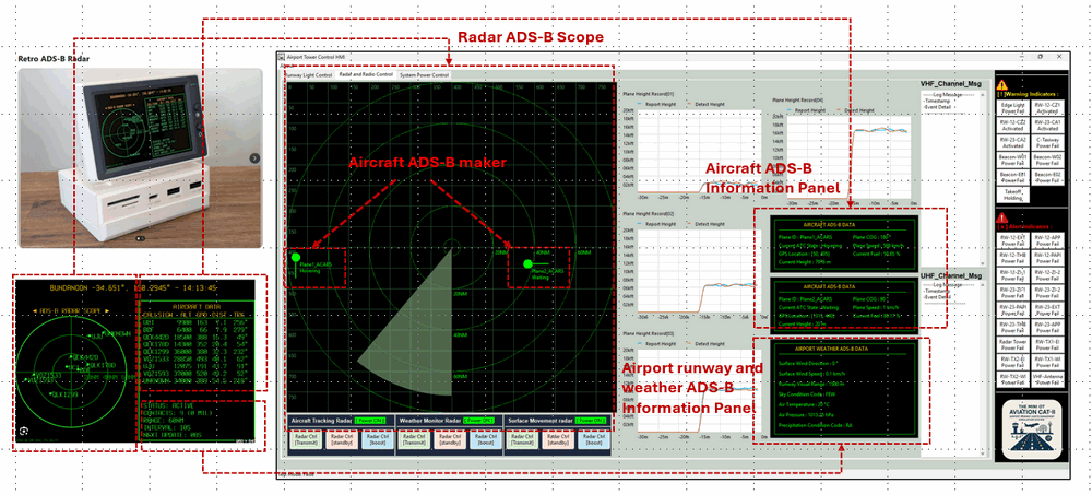
The Tower ATC control HMI represents the operator-facing interface of the aviation cyber range. It is implemented following the visual and interaction design principles of the Retro-ADSB-Radar project, combining classic radar-style visualization with modern data panels. By selecting the Radar and ATC Monitoring tab, the operator is presented with three primary ADS-B information panels. (As shown below)
Radar ADS-B Scope Display Panel
The Radar ADS-B Scope provides a radar-style visualization of the controlled airspace, overlaying real-time aircraft markers on an airport radar background.
-
Each aircraft marker represents:
Aircraft position (GNSS-based),Course Over Ground (COG)andRelative speed and movement direction. -
This panel serves as the primary situational awareness tool for monitoring traffic flow, separation, and airspace occupancy.
Aircraft ADS-B Information Panel
The Aircraft ADS-B Information Panel presents a list-based and detail-oriented view of ADS-B data received from the Ground Station ADS-B Controller via OPC UA.
-
Typical information displayed includes:
Aircraft identifier,Flight pattern ID,Current ATC operational state,Altitude,heading,airspeed,ground speed,Fuel stateandother aircraft-specific parameters. -
This panel complements the radar scope by providing precise numerical and state-based information for each aircraft
Airport Weather ADS-B Display Panel
The Airport Weather ADS-B Display Panel shows processed airport weather and operational information broadcast by the ground station.
-
Displayed information includes:
Surface wind direction and speed,Runway visual range and visibility,Sky condition and cloud coverage,Air temperature,Altimeter setting,PrecipitationandObscuration indicators. -
This panel allows ATC operators to quickly assess environmental conditions affecting airport operations, approach procedures, and traffic sequencing.
Conclusion and Reference
In summary, this project successfully implements a functional simulation of a Ground Station ADS-B Controller within an aviation cyber range environment. By modeling the core data acquisition, processing, and broadcast logic—and integrating it with a physical world simulator and a tower ATC HMI via OPC UA—the system provides a realistic yet distilled platform for understanding ADS-B workflows. This implementation offers a valuable foundation for conducting hands-on Operational Technology (OT) security training, system behavior analysis, and cybersecurity experimentation focused on modern aviation surveillance and communication systems.
Reference:
-
https://www.faa.gov/about/office_org/headquarters_offices/avs/offices/afx/afs/afs400/afs410/ads-b
-
https://www.linkedin.com/pulse/python-virtual-plc-simulator-iec-62541-opc-ua-tcp-protocol-liu-pm1pc
Thanks for spending time to check the article detail, if you have any question and suggestion or find any program bug, please feel free to message me. Many thanks if you can give some comments and share any of the improvement advice so we can make our work better ~
Merry Christmas and Happy New Year ~
last edit by LiuYuancheng ([email protected]) by 26/12/2025 if you have any problem, please send me a message.

No comment for this article.